

Destination guide · Philippines
Visayas Diving: Islas, resorts y cruceros
The Visayas bring several Philippine dive experiences into one island region: Dauin’s macro habitats, Apo Island’s reefs, Moalboal’s sardines and the shoals around Malapascua. A liveaboard connects selected areas, while a resort itinerary lets you spend longer in each.
Visayas de un vistazo
El Visayas es una región del centro de Filipinas en lugar de un solo lugar de buceo. Las laderas volcánicas macro, los arrecifes de tortugas, las paredes empinadas y los sitios costeros enfocados en tiburones se extienden entre diferentes islas, cada una con su propio carácter y arreglos de viaje.
Un liveaboard puede conectar partes seleccionadas de la región sin repetidos cambios de hotel; un itinerario de resort le permite pasar más tiempo en los lugares que más le interesan. Lea la ruta real cuidadosamente. Un crucero por Visayas puede explorar solo parte de Cebu, Bohol, Negros, Leyte o islas vecinas, y no se debe asumir que visita todos los destinos enumerados aquí.
Planificar su estancia en Visayas
Elija un liveaboard por las islas reales visitadas y los puertos de embarque y desembarque. Una combinación de resort es mejor cuando quieres más tiempo en tierra o inmersiones locales repetidas. Siete a doce noches es un marco útil para un crucero o una estancia de dos centros cuidadosamente a ritmo.
Liveaboard routes for this destination
Explore the routes that visit this region. Compare ships and itineraries, then open a route to see its sailing dates, cabins and the areas it covers.
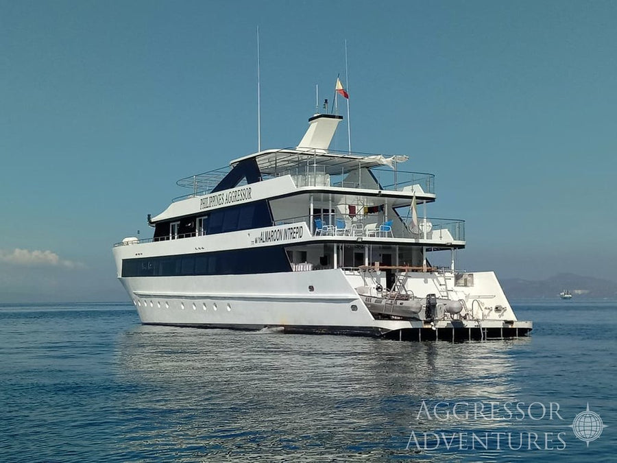
Philippines Aggressor
Islas Tubbataha y Visayas (10 noches)
- Indicative duration
- 10 nights
- Embarque
- Puerto Princesa
- Desembarque
- Cebu
Philippines Aggressor
Visayas - Sur (7 nights)
- Indicative duration
- 7 nights
- Embarque
- Cebu
- Desembarque
- Dumaguete
Philippines Aggressor
Visayas - Sur (7 nights)
- Indicative duration
- 7 nights
- Embarque
- Dumaguete
- Desembarque
- Cebu
Philippines Aggressor
Islas Visayas y Tubbataha (11 noches)
- Indicative duration
- 11 nights
- Embarque
- Cebu
- Desembarque
- Puerto Princesa
Philippines Aggressor
Islas Visayas (10 noches)
- Indicative duration
- 10 nights
- Embarque
- Cebu
- Desembarque
- Cebu
Philippines Aggressor
Islas Visayas (7 noches)
- Indicative duration
- 7 nights
- Embarque
- Cebu
- Desembarque
- Cebu
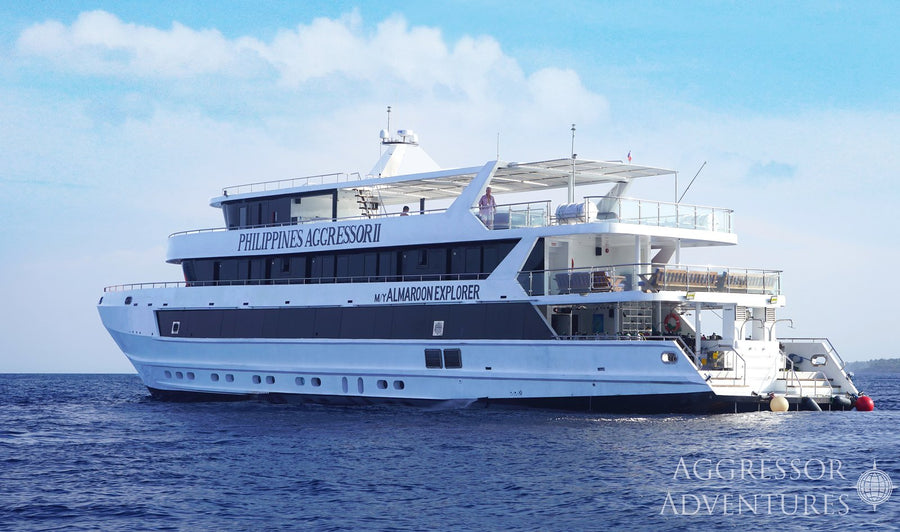
Philippines Aggressor II
Islas Tubbataha y Visayas (10 noches)
- Indicative duration
- 10 nights
- Embarque
- Puerto Princesa
- Desembarque
- Cebu
Philippines Aggressor II
Islas Visayas y Tubbataha (11 noches)
- Indicative duration
- 11 nights
- Embarque
- Cebu
- Desembarque
- Puerto Princesa
Philippines Aggressor II
Islas Visayas (10 noches)
- Indicative duration
- 10 nights
- Embarque
- Cebu
- Desembarque
- Cebu
Philippines Aggressor II
Islas Visayas (7 noches)
- Indicative duration
- 7 nights
- Embarque
- Cebu
- Desembarque
- Dumaguete
Philippines Aggressor II
Islas Visayas (7 noches)
- Indicative duration
- 7 nights
- Embarque
- Dumaguete
- Desembarque
- Cebu
Philippines Aggressor II
Islas Visayas (7 noches)
- Indicative duration
- 7 nights
- Embarque
- Cebu
- Desembarque
- Cebu
No routes match this search. Try another vessel or clear your search.
Cuándo bucear Visayas
El Visayas se bucea a lo largo del año, con muchos itinerarios concentrados en los meses más tranquilos desde aproximadamente noviembre hasta mayo. Las costas individuales y los cruces se comportan de manera diferente. Haga coincidir la ruta elegida con sus fechas de navegación publicadas y deje espacio para un pedido de sitio dirigido por condiciones.
Ventana de planificación: seleccione las fechas para las islas en su ruta.
Cómo es el buceo
Elija las islas y los sitios para adaptarse a la experiencia del grupo.
Dauin and Apo Island
El buceo macro de arena oscura a lo largo de Dauin contrasta con los arrecifes de coral y el hábitat de tortugas de Apo Island. Este emparejamiento da a los fotógrafos una razón para llevar tanto las opciones macro como gran angular.
Las diferentes costas de Cebu
Moalboal trae sardinas y paredes a la imagen, mientras que Malapascua es conocida por el buceo centrado en trilladoras. Se encuentran en diferentes partes de Cebu y necesitan su propio tiempo de viaje o un itinerario que los incluya explícitamente.
Bohol y las islas vecinas
Panglao, Balicasag y Cabilao ofrecen diferentes combinaciones de paredes, tortugas, jardines de coral y vida macro. Una estancia en el complejo de Bohol también crea espacio para el turismo rural.
Una ruta seleccionada para sus intereses
Elija un crucero por las islas y estilos de buceo que realmente cubre. Un viaje macro enfocado, un itinerario de arrecife y un programa de tiburones en alta mar se pueden describir como buceo Visayas, pero crean vacaciones muy diferentes.
DIVE SITE GUIDE
Dive sites in Visayas
These examples show the variety across the Visayas. They are not a single cruise itinerary: open each route to see which islands and dive areas it actually includes.
ORIENTATION MAP
Where the dive sites are
Use the map to understand how the key sites are spread around the destination. Pins are for trip-planning orientation only; entry points, moorings and the final dive plan are always confirmed by the local operator on the day.
Regional orientation only; the distance between islands matters when planning a journey.
Muck · Artificial reef · Macro
The Cars — Dauin & Apo Island
The Cars is one of Dauin’s most distinctive muck dives because the black-sand slope eventually leads to the remains of two vehicles and other artificial structure in the deeper part of the site.
Explorar este punto de buceo
- Tipo
- Muck · Artificial reef · Macro
- Profundidad
- 5–30 m
- Experiencia
- Open Water / Advanced for the cars
- Corriente
- Usually mild
The Cars is one of Dauin’s most distinctive muck dives because the black-sand slope eventually leads to the remains of two vehicles and other artificial structure in the deeper part of the site. The wreckage acts like a tiny oasis on an otherwise sparse seabed, attracting lionfish, morays, shrimp and a long list of smaller subjects.
The real pleasure is the approach: divers move slowly down the sand looking for frogfish, ghost pipefish, cuttlefish, seahorses and unusual nudibranchs before reaching the deeper structure. Open Water divers can enjoy the shallower macro zone, while the cars themselves sit beyond normal 18-metre limits and are better suited to Advanced divers, ideally with conservative gas and no-decompression planning.
Look for: Two sunken cars · Frogfish & ghost pipefish · Black-sand muck · Excellent photo dive
Ideal para: Macro photography · Frogfish · Ghost pipefish · Deep muck
Protected reef · Coral garden
Poblacion / Dauin Marine Sanctuary — Dauin & Apo Island
Poblacion shows the reef side of Dauin rather than its famous bare-sand muck habitat.
Explorar este punto de buceo
- Tipo
- Protected reef · Coral garden
- Profundidad
- 3–25 m
- Experiencia
- Beginner–Intermediate
- Corriente
- Mild–Moderate
Poblacion shows the reef side of Dauin rather than its famous bare-sand muck habitat. Inside the protected area, hard coral begins in very shallow water and slopes down toward roughly 25 metres, creating an easy place to combine reef fish, coral scenery and the possibility of turtles with a relaxed profile.
It is a useful first dive for guests arriving in Dauin because the shallow section allows buoyancy checks without sacrificing marine life, while photographers can move between wider coral scenes and smaller subjects tucked into the reef. The sanctuary can also work well for mixed-experience groups: newer divers stay on the upper slope, while more experienced divers can explore deeper sections without turning the dive into a demanding current or depth exercise.
Look for: Marine protected area · Hard-coral slope · Turtle potential · Good check dive
Ideal para: Healthy hard coral · Turtles · Easy reef diving
Offshore shoal · Shark cleaning station · Deep
Monad Shoal — Malapascua Island
Monad Shoal built Malapascua’s international reputation.
Explorar este punto de buceo
- Tipo
- Offshore shoal · Shark cleaning station · Deep
- Profundidad
- 18–30+ m
- Experiencia
- Advanced
- Corriente
- Variable
Monad Shoal built Malapascua’s international reputation. The submerged plateau sits beside a very deep drop-off and is used by pelagic thresher sharks visiting cleaning stations around the reef. The experience is usually less about swimming around the site and more about positioning carefully, staying calm and allowing the sharks to approach on their own terms.
Good buoyancy and disciplined depth control matter because useful viewing areas can be relatively deep, and Nitrox is often valuable for extending no-decompression time. Mantas, devil rays and other pelagics may also appear, but no sighting is guaranteed. The dive is at its best when treated as a patient wildlife observation rather than a chase for close photographs.
Look for: Thresher shark cleaning station · Deep offshore shoal · Pelagic potential · Advanced profile
Ideal para: Thresher sharks · Pelagic photography · Nitrox profiles
Pinnacle · Oceanic shoal · Pelagic
Kimud Shoal — Malapascua Island
Kimud Shoal is a deeper, more oceanic counterpart to Malapascua’s other shark dives.
Explorar este punto de buceo
- Tipo
- Pinnacle · Oceanic shoal · Pelagic
- Profundidad
- 12–40 m
- Experiencia
- Advanced
- Corriente
- Variable / can be strong
Kimud Shoal is a deeper, more oceanic counterpart to Malapascua’s other shark dives. The top of the submerged island begins around 12 metres before its sides fall into very deep water, creating the kind of edge where divers naturally watch both the reef and the blue.
Thresher sharks are now an important reason operators visit, while hammerheads, devil rays, eagle rays and tuna remain possible rather than guaranteed encounters. Because the useful part of the site may involve current, depth and open-water positioning, it is best for experienced divers who are comfortable following a strict group plan. A calm approach matters here too: the site rewards situational awareness and patience far more than aggressive pursuit of wildlife.
Look for: Oceanic shoal · Thresher shark potential · Hammerhead potential · Rays & tuna
Ideal para: Thresher sharks · Hammerhead potential · Rays · Blue-water diving
Slope · Wall · Drift
Black Forest, Balicasag — Bohol & Balicasag
Black Forest is one of Balicasag’s signature dives because the reef changes character as it descends.
Explorar este punto de buceo
- Tipo
- Slope · Wall · Drift
- Profundidad
- 8–35 m
- Experiencia
- Intermediate
- Corriente
- Mild–Moderate
Black Forest is one of Balicasag’s signature dives because the reef changes character as it descends. The upper slope is bright and fish-filled, while deeper sections are known for dark coral growth, larger fans and a more open-water feeling.
Turtles are frequent around the island and schools of jacks or barracuda may move through the blue when current is running. The best route follows the contour rather than forcing a fixed depth, letting the group spend time where fish activity is strongest. It is a very photogenic dive, but the deeper slope can tempt divers down, so good depth discipline is important even when the current feels easy.
Look for: Balicasag classic · Turtles · Schooling fish possible · Black-coral habitat
Ideal para: Turtles · Jacks · Black coral · Drift diving
Wall · Overhangs · Reef
Cathedral Wall, Balicasag — Bohol & Balicasag
Cathedral Wall is named for the way light enters cracks, fissures and overhangs in the reef face, creating shafts and shadowed spaces that give the wall a more architectural feel than a simple drop-off.
Explorar este punto de buceo
- Tipo
- Wall · Overhangs · Reef
- Profundidad
- 5–30 m
- Experiencia
- Intermediate
- Corriente
- Mild–Moderate
Cathedral Wall is named for the way light enters cracks, fissures and overhangs in the reef face, creating shafts and shadowed spaces that give the wall a more architectural feel than a simple drop-off. Divers can stay outside the openings and still get the full effect; there is no need to treat the site as an overhead-environment dive.
Turtles and reef fish are common around Balicasag, while fans, sponges and coral decorate the wall. The combination of vertical scenery and changing light makes this one of the island’s strongest wide-angle sites, especially when visibility is good and the group can move slowly along the face.
Look for: Wall topography · Light shafts · Turtles · Wide-angle photography
Ideal para: Wall scenery · Cavern-like light · Turtles · Wide angle
Shore dive · Reef wall · Schooling fish
Panagsama Sardine Run — Moalboal
The Panagsama Sardine Run is extraordinary because the headline experience begins only a short swim from shore.
Explorar este punto de buceo
- Tipo
- Shore dive · Reef wall · Schooling fish
- Profundidad
- 3–18 m
- Experiencia
- Beginner
- Corriente
- Usually mild
The Panagsama Sardine Run is extraordinary because the headline experience begins only a short swim from shore. A huge resident school holds near the reef drop-off, changing shape constantly as predators, divers and light move around it. The best dive is not to chase the school but to position beside it and let the sardines flow overhead, opening and closing into walls, funnels and tornado-like formations.
Green turtles are frequently seen along the same reef, while jacks and mackerel may hunt at the edge of the baitball. Because the action is shallow, bottom time can be long and even newer divers can experience it comfortably. The school’s exact position shifts, so guides locate it on the day rather than relying on one fixed marker.
Look for: Resident sardine school · Shore access · Turtles · Excellent wide angle
Ideal para: Sardine baitball · Turtles · Photography · Easy shore access
Wall · Reef · Cavern
Pescador Island — Moalboal
Pescador Island is Moalboal’s classic boat dive, a small offshore rock surrounded by steep reef and deep water.
Explorar este punto de buceo
- Tipo
- Wall · Reef · Cavern
- Profundidad
- 7–30+ m
- Experiencia
- Intermediate
- Corriente
- Variable
Pescador Island is Moalboal’s classic boat dive, a small offshore rock surrounded by steep reef and deep water. The north and west sides drop into dramatic walls, while the southern side offers a gentler slope. The famous Cathedral area adds cavern-like topography and shafts of light, and the reef itself carries hard coral, smaller macro subjects and schooling fish.
Divers may see barracuda, tuna and the occasional reef shark, but the site is worth diving even without pelagics because the wall and coral structure are so strong. Current can range from almost still to a fast drift, so the operator normally chooses the entry point according to tide and group experience. It is the natural place to use a wide-angle lens in Moalboal.
Look for: Iconic island wall · Cathedral topography · Coral & schooling fish · Current-dependent
Ideal para: Wall diving · Cathedral cavern · Reef fish · Wide angle
Fotografía submarina
Construye el plan de la cámara alrededor de las islas reales en tu itinerario. Dauin macro, las sardinas de Moalboal y una inmersión de tiburón Malapascua exigen diferentes enfoques. En un crucero, prepárese para los sitios anunciados al día siguiente; en un viaje turístico, repita un sitio productivo cuando desee tiempo para mejorar una imagen en particular.
Más allá del buceo: Visayas sobre la superficie
La región más amplia ofrece suficiente variedad de tierra para unas vacaciones que no se trata exclusivamente de buceo. El campo de Bohol, las cascadas de Siquijor, el paisaje interior de Cebu y la vida costera alrededor de Dumaguete aportan algo diferente al viaje.
Estas son islas separadas con tiempo de viaje real entre ellas. Elija dos o tres bases complementarias en lugar de tratar de recoger cada nombre de lugar. La ruta de un liveaboard es también una selección de la región, no una promesa de visitar todos los destinos que se muestran en esta guía.
Cómo llegar a Visayas
Cebu es una puerta de entrada común para los viajes de Visayas, pero cruceros individuales y estancias en islas pueden usar diferentes puertos y aeropuertos. Dumaguete y Bohol pueden ser útiles para programas turísticos específicos. Siempre construya el plan de viaje alrededor de las islas seleccionadas en lugar de una etiqueta regional genérica.
Las transferencias entre islas toman tiempo. Algunas bases bien elegidas generalmente hacen unas vacaciones más agradables que cambiar de isla todos los días, y una ruta de crucero puede ser una forma práctica de conectar lugares cuando sus puertos de embarque y desembarque se adaptan al viaje más amplio.
Preguntas de buceo Visayas
¿Todas las rutas de Visayas visitan todas estas islas?
Un liveaboard puede conectar partes seleccionadas de la región sin repetidos cambios de hotel; un itinerario de resort le permite pasar más tiempo en los lugares que más le interesan. Lea la ruta real cuidadosamente. Un crucero por Visayas puede explorar solo parte de Cebu, Bohol, Negros, Leyte o islas vecinas, y no se debe asumir que visita todos los destinos enumerados aquí.
¿Cómo debo planificar mi estancia?
Elija un liveaboard por las islas reales visitadas y los puertos de embarque y desembarque. Una combinación de resort es mejor cuando quieres más tiempo en tierra o inmersiones locales repetidas. Siete a doce noches es un marco útil para un crucero o una estancia de dos centros cuidadosamente a ritmo.
¿Cuándo es un momento útil para visitar?
El Visayas se bucea a lo largo del año, con muchos itinerarios concentrados en los meses más tranquilos desde aproximadamente noviembre hasta mayo. Las costas individuales y los cruces se comportan de manera diferente. Haga coincidir la ruta elegida con sus fechas de navegación publicadas y deje espacio para un pedido de sitio dirigido por condiciones.
¿Hay suficiente para los compañeros que no bucean?
La región más amplia ofrece suficiente variedad de tierra para unas vacaciones que no se trata exclusivamente de buceo. El campo de Bohol, las cascadas de Siquijor, el paisaje interior de Cebu y la vida costera alrededor de Dumaguete aportan algo diferente al viaje.
A closer look at Visayas


Planifica tu viaje a Visayas
Cuéntanos las experiencias que más te gusten, tus fechas preferidas y cómo te gusta viajar. Podemos traer el destino, alojamiento y buceo en un itinerario coherente.
Planificar mi viajeCréditos fotográficos
Las imágenes se redimensionan para su visualización y pueden recortarse para adaptarse al diseño de la página.
- Densa escuela de sardinas en Moalboal, Cebu, en el Visayas: 2014 11 Moalboal 21 sardine run (16024303526).jpg — Lakshmi Sawitri. CC BY 2.0. Imagen de tamaño web suministrada por Wikimedia Commons; ninguna edición de escena.
- Tiburón Thresher fotografiado frente a la isla de Malapascua, Filipinas: Tresher1.jpg — James Heilman, MD. CC BY-SA 4.0. Imagen de tamaño web suministrada por Wikimedia Commons; ninguna edición de escena.
- Peces de arrecife amarillos y corales ramificados en la isla Balicasag, Bohol: Balicasag Reef.jpg — Thomas Brown. CC BY 2.0. Imagen de tamaño web suministrada por Wikimedia Commons; ninguna edición de escena.
- Vista aérea de la isla Pescador frente a Moalboal, Cebu: Pescador Island (Unsplash).jpg — Ken Suárez kensuarez. CC0. Imagen de tamaño web suministrada por Wikimedia Commons; ninguna edición de escena.
- Tortuga marina descansando entre corales en Apo Island, Negros: Sleepy Turtle in Apo Island.jpg — Anna Varona. CC BY 4.0. Imagen de tamaño web suministrada por Wikimedia Commons; ninguna edición de escena.
- Apo Island vista desde el mar frente a Negros Oriental: Apo Island east.jpg — Mike Gonzalez (TheCoffee). CC BY-SA 3.0. Imagen de tamaño web suministrada por Wikimedia Commons; ninguna edición de escena.
- Cúmulo de tunicados translúcidos fotografiados en Apo Island: Tunicates (6851439624).jpg — Elias Levy. CC BY 2.0. Imagen de tamaño web suministrada por Wikimedia Commons; ninguna edición de escena.
- Barco siluetado contra la puesta del sol en San Juan, Siquijor: San Juan, Siquijor.jpg — Jerche Amada. CC BY-SA 4.0. Imagen de tamaño web suministrada por Wikimedia Commons; ninguna edición de escena.


